Click here to go to the SHIPTON GORGE RAMBLERS page...
There are approximately 3,000 miles of Rights of Way in Dorset. The 'Definitive Map' of all Rights of Way was drawn in 1989 and is held by Dorset County Council (DCC) and the Rights of Way Liaison Officer of Shipton Gorge Parish Council. However, the definitive map is now out of date and more recent maps can be found here: Definitive map and statement - Dorset Council. The scale of the electronic maps can be altered to view the whole of Dorset through to individual houses, so - although the maps are labelled 'not definitive' - they are more clear than previous maps. |
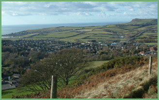 There are lots of opportunities for residents and visitors to go off the beaten track by using the 18 public footpaths and 7 bridleways within the parish. Some go across fields, some through woods and others alongside streams and beside ponds. A number of the paths go to Shipton Hill which provides a wonderful viewpoint of the village and the whole Bride Valley. There is no public footpath to the top of the hill but there is a "right to roam" over the top, or alternatively the walk around the hill is well worthwhile.
 In 1989 a new Definitive Map of the public rights of way was produced and this is held by the Parish Council's Rights of Way Officer as well as being on the cover of the 1989 Village Appraisal.
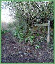
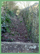
There have been a few changes to the paths over recent years but they are easy to follow. There are signposts from all the tarmac roads and follow up markers along the routes. Some paths have wooden stiles, others old stone stiles and stepping stones.
Footpaths and bridleways are maintained by Dorset County Council and the landowners. Any queries or comments regarding footpaths or bridleways in the parish should be made in the first instance to the Parish Council's Rights of Way Liaison Officer or to the Parish Clerk.
 During the 1980s, the late Miss Joan Ballard devised some walks along the footpaths and bridleways in the parish and these were then compiled into a booklet, of which some copies are still available. Most of these walks started in the centre of the village at what was then the village shop and post office. This has since closed and the property returned to a residence but her walks are still relevant to us now and great fun if you can track down a copy of the booklet! Joan Ballard was the Parish Council's Rights of Way Liaison Officer for many years and the proceeds from her booklet were donated to the Royal National Lifeboat Institution. So everyone benefited - the RNLI and the many walkers who wanted to explore our village.
If you find any problems with blocked Rights of Way or damaged stiles or gates, please inform the Rights of Way Liaison Officer who will pass the information onto DCC or you can report issues yourself here: Rights of way - Dorset Council or contact your councillor.
Thank you.
Below is the list of paths with their grid numbers:
Footpath 1 - From Cuckoo Lane (Grid ref. 497915) to join Path No. 2 (Grid ref. 499915)
Footpath 2 - From Smacombe Lane (Grid ref. 499917) to Brook Street (Grid ref. 499915)
Footpath 3 - From Barr Lane (Grid ref. 497919) to Cobbett Hill (Grid ref. 497922)
Footpath 4 - From Cobbett Hill (Grid ref. 497922) to Loders Parish boundary, east of Innsacre (Grid ref. 497925)
Footpath 5") - From Smacombe Lane (Grid ref. 500916) to join Path No. 6 East of Shipton Hill (Grid ref. 508921)
- From Smacombe Lane (Grid ref. 500916) to join Path No. 6 East of Shipton Hill (Grid ref. 508921)
Footpath 6 - From Icen Lane, via Shipton Hill (Grid ref. 513921) to Loders/Shipton Lane at the Parish boundary (Grid ref. 503923)
Footpath 7 - From St Luke's Farm (Grid ref. 516923) to Cuckold's Corner (Grid ref. 518925).
Note that the entrance onto this footpath is blocked and it is suggested that walkers go through gateway north of St Luke's Farm instead.
Footpath 8 - From Bridleway no. 14 at Hammiton Wood, via Lower Sturthill Farm (Grid ref. 513916) to Chilcombe Road (Grid ref. 524920)
Footpath 9 - From Footpath no. 8 (Grid ref. 517916) to join Path no. 17 (Grid ref. 517917)
Footpath 10 - From Footpath no. 11 near Lower Sturthill Farm (Grid ref. 521916) to Chilcombe Parish boundary (Grid ref. 524915)
Footpath 11 - From Footpath no. 8 at Lower Sturthill Farm (Grid ref. 521917) to Chilcombe Parish boundary (Grid ref. 524915)
Bridleway 12 - From road at Higher Sturthill Farm (Grid ref. 512920) to Loders Parish boundary at Shipton Hill (Grid ref. 509922)
Footpath 13 - From the A35 Bridport/Dorchester road at Nine Bottles (Grid ref. 523924) to Chilcombe Lane (Grid ref. 524922)
Bridleway 14 - From Icen Lane at Hammiton Wood (Grid ref. 510916) to Chilcombe Parish boundary (Grid ref. 524909)
Bridleway 15 - From Icen Lane via Hammiton Hill (Grid ref. 509915) to Burton Bradstock Parish boundary (Grid ref. 510908)
Bridleway 16 - From bridleway no. 15 (Grid ref. 510911) to Burton Bradstock Parish boundary and thence to Cathole Copse (Grid ref. 509910)
Bridleway 17 - From St Luke's Farm (Grid ref. 516921) to Burton Bradstock Parish boundary (Grid ref. 516914)
Footpath 18 - From Brook Street (Grid ref. 498915) to Burton Bradstock Parish boundary at Cathole Copse (Grid ref. 501908)
Footpath 19 - From Footpath no. 18 at St Martin's Church (Grid ref. 498914) to St Catherine's Cross (Grid ref. 495907)
Footpath 20 - From Shipton Road at The Plot (Grid ref. 496912) to lane near Village Hall (Grid ref. 4979150), also joining bridleway 18 and path 19 (Grid ref. 498914)
Footpath 21 - From Burbitt (or Burport) Lane (Grid ref. 494915) to Milvers Lane near Bennett's Hill Farm (Grid ref. 488909)
Bridleway 22 - From lane west of Milvers Lane (Grid ref. 486916) to Bothenhampton Parish boundary (Grid ref. 484915)
Footpath 23 - From Burbitt (or Burport) Lane (Grid ref. 491916) to Bothenhampton Parish boundary and thence to Walditch (Grid ref. 485919)
Bridleway 24 - From Bonscombe Farm (Grid ref. 492921) to Bothenhampton Parish boundary (Grid ref. 489923)
Footpath 25 - From junction of path no. 6 at Icen Lane (Grid ref. 513921) to Loders Parish boundary, thence to former Travellers Rest public house (Grid ref. 515924)
When walking in the country you should know the countryside code:
- Enjoy the countryside and respect its life and work.
- Guard against all risk of fire.
- Fasten all gates.
- Keep your dogs under close control.
- Keep to public paths across farmland.
- Use gates and stiles to cross fences, hedges and walls.
- Leave livestock, crops and machinery alone.
- Take your litter home.
- Help keep all water clean.
- Protect wildlife, plants and trees.
- Take special care on country roads.
- Make no unnecessary noise.
The official website for the Countryside Code and maps of Open Access land in England is
www.naturalengland.org.uk